Seskinore Forest – a hidden treasure?

Some of the courtyard buildings at Seskinore Forest, the main courtyard was sealed off from public access.

Every Saturday I try and do some physical exercise either cycling around Omagh or going for a walk – last Saturday was no exception and I had spotted on the WalkNI website that Seskinore Forest had a choice of routes at 2.8, 3.6 or 4.8 miles so myself and a friend decided to investigate as I had never been there before.

At just over 6 miles from Omagh (over a mile closer than Gortin Glen Forest Park) it didn’t take long to get there and the forest was well sign posted off the B83 Seskinore Road. The entrance takes you along a tree lined avenue to a parking area where parking is free (a saving of £3.50 on the Gortin Glen parking charge!). There was ample space to park when we went as we were the only people there on a beautiful Saturday afternoon!

We got out of the car and proceeded towards the courtyard buildings only to find that there was no signposts or information board. The WalkNI webpage on the forest provided no map (see update below) nor did the Forest Service page on nidirect, a web search yielded nothing either and the poor mobile signal meant that a satellite image from Google Maps was out of the question, we were going to have to explore the forest Christopher Columbus style!

I assume this was used for tying up horses?
One of at least two metal posts outside some of the courtyard buildings (possibly the stable?) – I assume this was used for tying up horses?

We headed towards a wooded area and started walking and within ten minutes had arrived at an old gate onto the public road (one of many we would find on our exploration!), we spotted a trail to the right and followed it around to the Chapel of Ease which then took us back to the courtyard again within perhaps a further 15 minutes. We decided to walk towards the main entrance to see if there were any other options in that direction but we reached the main road. There was a gate opposite that looked like it was a possible continuation of the forest but signs posted about a ‘Pheasant shoot’ did not encourage us to proceed further so we turned and headed back to the car park.

Rabbits were in abundance and we spotted a number of rabbit burrows throughout the forest. It was at this point we noticed another trail leading off from the car park, we followed it and turned left onto a forest road after ten minutes this lead us to another dead end – gate posts with a gate missing replaced with some wooden fencing. We turned back and on the way back towards the car park noted another trail off to the left. It was quite mucky but we navigated it successfully and it lead to a narrower stretch of woodland with some interesting man-made features:

Potentially an area for cold storage?
Perhaps a shed or storage area at one time?

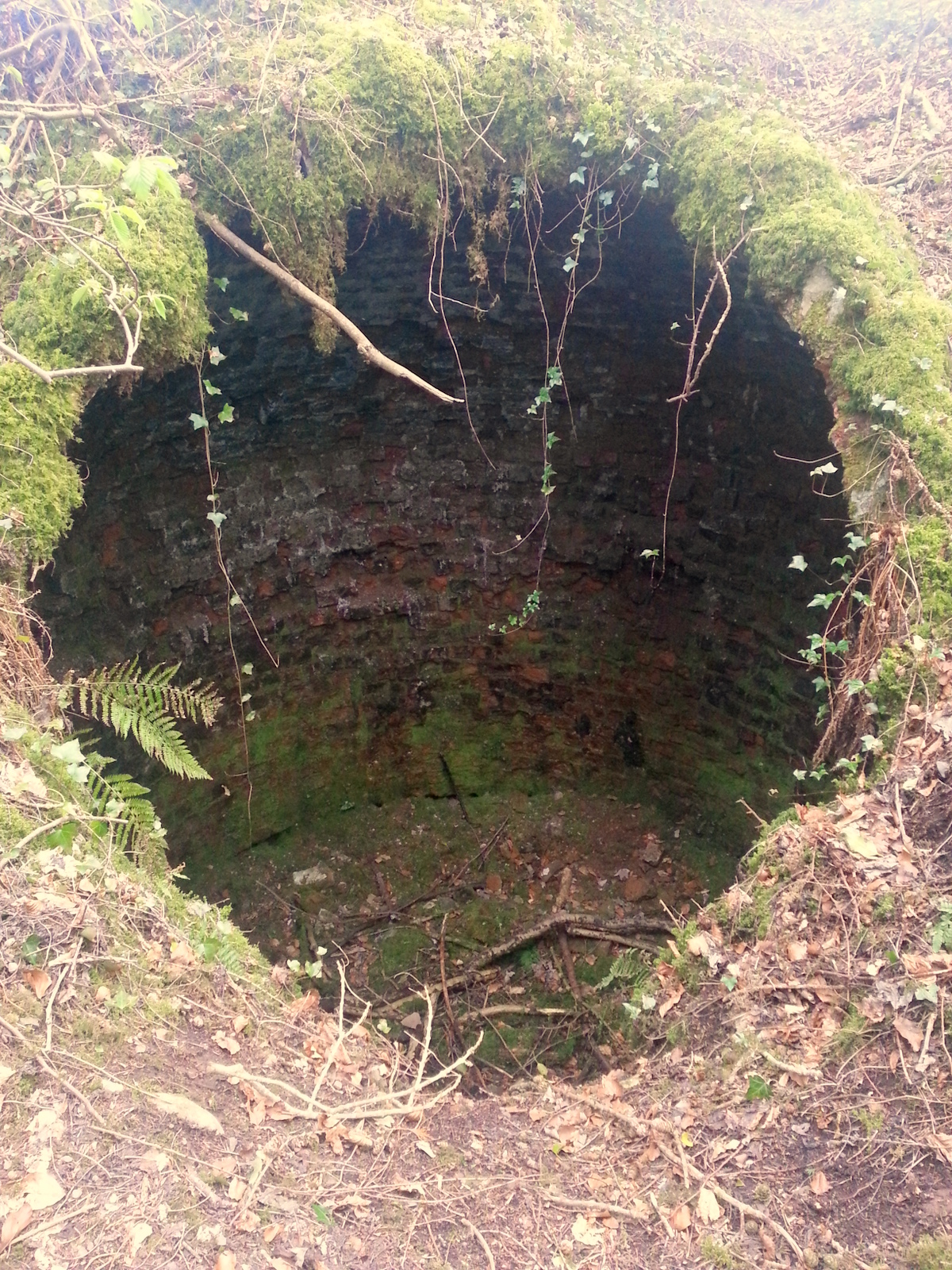
We continued onwards and came to a deep trench with a few inches of water in it, a log had been placed across it but it certainly wasn’t a safe way to cross although my friend tried it regardless. There was a dry section that I used to cross which appeared to have been used many times before. We then came across a small fenced off square section with the following warning sign:

Danger - Keep Clear of Fire Dam
Danger – Keep Clear of Fire Dam

We proceeded onwards and eventually came across another small road that led to another gate, we crossed the road and spotted a trail that continued round to a small fenced off area with a small sign inside it which turned out to be the McClintock family memorial garden. On further research we found that the forest and courtyard buildings are all that remain of the McClintock Estate. It was handed over to the Ministry of Agriculture in 1941.

Entrance to the memorial garden and final resting place of members of the McClintock Family who once owned the grounds of the present day Seskinore Forest.

The sign also had a historical map which enlightened us as to our location in relation to the rest of the estate:

A historical map of Seskinore Forest which appears to be still somewhat accurate today.

Having seen the map we went back to the courtyard area to investigate where the original house would have stood, we found an area of grass where we assume it stood and noted that opposite this location across a further expanse of grass was the following structure:

Perhaps a garden ornament at one stage?

Unfortunately right next to this unusual structure there was a lot of unsightly black plastic that had been partially grown over. We had also spotted some earlier on our exploration – what was inside we did not investigate however it did take away from the natural surroundings.

We spotted black plastic in quite a few locations - some of it was grown over in other places bags were abandoned.
We spotted black plastic in quite a few locations – some of it was grown over in other places bags were abandoned.

On our route back to the car we circled the courtyard to try and get some better views of the area blocked off from the public and we came across another walled area that at one time must have been a deer enclosure – however we could see no sign of any animal life there when we visited.

A caution sign about male deer at Seskinore Forest.

All in all it was a couple of hours well spent however much of the forest/estate feels run down with boarded up windows, the rusty gates, missing gates and black plastic to name but a few issues. The lack of information signs, maps or pointers to highlight some of the interesting features seemed a shame and seemed to disrespect what must have been at one time quite a grand working estate. Only that we had the determination to explore as much as we did we would never have found half of the things we saw. It seems like it wouldn’t have taken much effort to give the place a spring clean and a small investment in an information board and a few pointers would have made it much easier for the visitor to fully appreciate the forest and estate. With a few small improvements this could be a great hidden gem in the Tyrone countryside.

In the end though we are still not sure where the walking routes listed on the WalkNI website actually are – did they include the ‘pheasant shoot’ land? Was it on the main roads surrounding the forest? I really don’t know but I would say we walked about 2.5 miles, had explored most of the area outlined on the historical map, had taken most of the trails we could see and double backed a few times in the process as well! In short I don’t know – if anyone has any more local knowledge please feel free to share by leaving a comment below!

Update #1

WalkNI have responded to my comment on the walk web page. They have said that they provide maps and route descriptions for all ‘Quality Walks’ in NI but that Seskinore has not been deemed a ‘Quality Walk’ as there is very little management or maintenance of the walking routes provided by Forest Service NI. They mentioned that Forest Service NI’s primary focus is on timber production and the forest parks but that they may be willing to work in partnership with another body who would be interested in taking on the management and maintenance of the routes such as Omagh District Council and have suggested contacting the leisure department to make this suggestion. They have also pointed out that current legislation states that members of the public are free to access all Forest Service NI land on foot and have provided me with a map of the forest boundaries. It is clear from looking at the map that we covered only around one third of the forest and should have walked into the ‘Pheasant Shoot’ land to explore the rest of the forest.

The A5 – A Commuter’s Perspective

The A5 Road

The Road

The A5 is a major primary route in Northern Ireland that runs from Craigavon Bridge in the city of Derry-Londonderry to the border at Aughnacloy where it forms the N2 which ultimately leads to Dublin. As it is the main route connecting the North West of Ireland with Dublin it is in several places referred to as the ‘North-West Passage’. The A5 road is approximately 54 miles long and is mainly single carriageway with a few 2+1 passing sections along the route.

The Commute

The A5 Omagh to Derry-Londonderry section is my daily commute, a distance of around 34 miles it usually takes 55-mins to 1 hour when leaving Omagh at 7am. The return journey leaving Derry-Londonderry at 5.30pm usually takes between 1 hour and 1 hour 10 mins. I have been a regular commuter on the route from February 2008 to the present day with the exception of 2011 when I worked in the USA. I am also very familiar with the stretch of road south of Omagh as it is the town’s primary route to Belfast and Dublin.

With the exception of the 2+1 purpose-built passing sections there are few other safe places to overtake traffic due to the fact that road continually twists and bends to follow the rivers Strule, Mourne and Foyle.

The maximum speed limit on the road for cars is 60mph with lower speed limits at Kelly’s Inn cross roads, Omagh by-pass, Sion Mills, Strabane by-pass, Ballymagorry, Bready, Magheramason, New Buildings and Derry-Londonderry. Outside of these settlements the maximum speed limit can rarely be reached due to farm vehicles, heavy goods vehicles (HGVs), learner drivers and restricted drivers travelling at slower speeds. With few opportunities to overtake as mentioned previously this can result in long slow tail backs at peak travelling times. I regularly see Ambulances struggling to pass traffic in their efforts to get to Altnagelvin Hospital, one of the main Acute Hospitals in the West following the closure of the Tyrone County Hospital’s A&E Department back a few years ago.

In the period 2004-2009 there were 19 fatalities along the A5. I personally have lost count of the number of near misses I have witnessed with my own eyes with people trying to overtake in dangerous manoeuvres.

Aside from the tragic loss of the life, the lack of alternative routes in the area causes problems following the resulting road closure after any sort of accident. These closures can increase travel time significantly with detours of up to 10-15 miles in place along narrow country roads.

The Project

In 2007 funding was announced and the NI Executive agreed to proceed with the A5 Western Transport Corridor (WTC) plan, an ambitious project that aimed to dual the entire length of the A5 route. The project has suffered considerable setbacks with the Irish Government not providing funding for the parts of the scheme they agreed to resulting in only two sections of the route now being considered for an upgrade (New Buildings to Strabane and Omagh to Ballygawley).

More details on the project and a history of what has happened so far can be found on the fantastic NI Roads website: A5 Dualling Derry to Aughnacloy.

The Opposition

More recently there has been a legal challenge from The Alternative A5 Alliance (AA5A) a group of 18 individuals opposed to the scheme. On 12th March the judge rejected 5 of their 6 challenges, but upheld one regarding the failure of the DRD carry out an appropriate assessment of the Rivers Foyle and Finn Special Areas of Conservation under the Habitats Directive. On Monday 8th April we learned that the High Court Judge, Mr Justice Stephens, confirmed he was quashing the decision to go ahead with the £330M dual carriageway project. However he granted the DRD a seven day stay to lodge any appeal to his ruling – until 12:00 on Monday 15th April.

The Future

Further details on the possible implications of this ruling can be found on Wesley Johnston’s article in which he states that the ruling is against a procedural issue regarding a breach of the habitats directive and is not a ruling against the route or concept of the project itself and would not permanently prevent the road from being built.

The reality is that because a process wasn’t followed correctly significant time has been added to an already delayed project, exposing commuters and the public to the current risks for a longer period of time and ultimately the cost of these delays will all be at the tax payer’s expense.

The Hope

As a commuter I believe it is essential that the entire route is dualled to provide a safer road for all and to significantly reduce travel time (to perhaps 30 minutes in my case – 35 miles @ 70mph = 30 mins). With the dualling of the A4 to Ballygawley complete, continuing this on the A5 to Omagh would give an uninterupted dual carriageway connection to Belfast reducing the potential travel time to Belfast to just 1 hour. These faster travel times and better connections can only improve our local economic opportunities and provide the west of the Northern Ireland with the infrastructure it deserves.

Until then we’ll just have to keep driving with perseverance and patience…

“Life is a journey that must be traveled no matter how bad the roads and accommodations.” – Oliver Goldsmith

The A5 Road - Mountjoy